Solutions
Urban Development

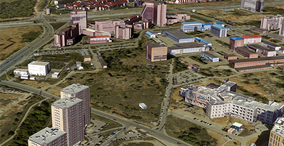
3D object model
Kommunarka, 2018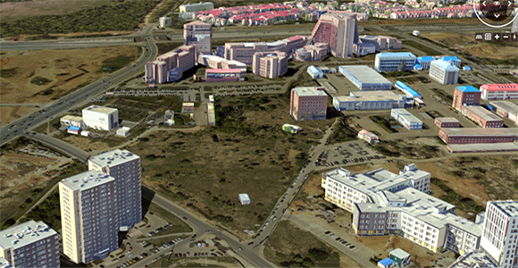
3D object model for change detaction
Kommunarka, 2019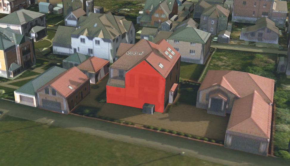
3D object model – measurements on the facade
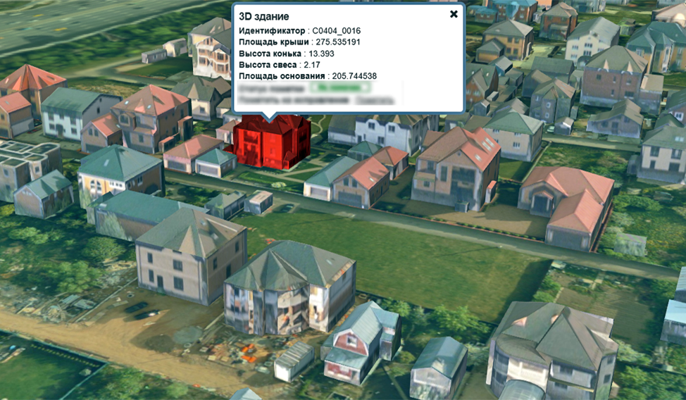
3D object model with cadastral form
Urban, city, or town planning is the discipline of land use planning which explores several aspects of the built and social environments. Aerial survey data be used to create highly detailed DSMs and eventually Digital City Models. This technology allows large area models to be created in very short space of time. Accurate digital models are required today for many applications.
Design and construction
- Development of the topographic base for General Plans of cities and settlements,
- Preparation of area demarcation plans,
- Development of the unified digital reference cartographic base at the most detailed level,
- Topographic surveys of 1:500-1:2000 scales for obtaining permits for construction and for the needs of operating organizations.
Situational modeling
- Simulation of virtual reality scenes of project facilities and urban landscape based on the oblique aerial photography and laser scanning data,
- Creation of situational maps for emergency and other urban services,
- Terrain modeling for housing and utility sectors (uncovering the areas prone to flooding, endogenous geomorphological processes, etc.),
- Environmental modeling and predictive analysis - modeling of air masses and pollution, maps of noise pollution.
Municipal geographic information systems
Development of the territory, urban planning and infrastructure management is associated with the following information stored in the data array of municipal GIS:
- Topographic maps of different scales,
- Cadastral information,
- Scheme of transport and utility networks,
- Social infrastructure plans,
- Geological, hydrogeological, and environmental characteristics,
- Urban planning regulations and documents
The faster information processing makes it possible to optimize the land use, as well as to analyze and timely and accurately forecast various processes.
Moreover, GIS helps increase the efficiency of existing industrial and logistics schemes and find new, more efficient one.
Solutions
Urban Development
3D object model
Kommunarka, 20183D object model for change detaction
Kommunarka, 20193D object model – measurements on the facade
3D object model with cadastral form
Modern city is a complex multi-level structure consisting of many interoperable systems supporting the city functions. The digital information and communication technologies are implemented to manage cities, to enhance the quality, performance, and interactivity of urban services, and to reduce costs and resource consumption. The digital twins being integral to the Smart City conception are developed.
Since 2014 Sigma Metrix has been creating 3D city models – the CityGML-based digital twins. Using our software, it is possible to automatically create the accurate geometric models of all free-standing buildings in the territory and to texturize the wall and roof surfaces fully automatically.
The major difference of our models is that each building is represented by a separate geometric model (object) with the exact coordinate references and orientation in a local coordinate system. Each model can have any quantity of text attributes (address, designated purpose, number of storeys, ownership, easements, floor space, volume, etc.). The attributes can be read from external data warehouses or be set on site. Models can be removed from the scene, migrated and merged, and the operations can be carried out both in the customer's local network and Internet environment.
All geometric models are stored in a standardized spatial data format – CityGML, which was developed and accepted by the Open Geospatial Consortium (OGC). Today it is an open platform to develop information and analytical systems for municipal administration.
It is significant that all the models "stand" on the real terrain, which makes it possible to build a single integration platform for various geospatial systems and services. This is a vivid model of the set of urban objects, which shows them in the dynamics as well, for example, in the development using the interfaces with BIM models.
The applications of 3D object models
- Visualization of the existing landscape and comparison with the current/future renovation or reconstruction projects - to coordinate activities of several contractors, optimize the design and construction processes, and control the compliance with the project documentation.
- Design of infrastructure, travel routes to redirect the human and traffic flows and to minimize any inconvenience to the citizens.
- Automatic geometric change detection of the features (area, number of storeys, etc.) occurred after the previous survey - for cadastral accounting and taxation.
- 3D cadastre.
- Assessment of the energy consumption to regulate the heating intensity, duration of heating season depending on the thermal efficiency in different buildings, the need and cost of renovation of heating systems. The model combines information about the building volume, number of floors, building type, and other characteristics to forecast the heating energy demand.
- Operational models of utilities - visualization of the requirements for repair, potentially accident-prone joints and junctions, and conductivity values.
- Ecological modeling and predictive analysis – movement simulation of air masses and emissions, noise pollution maps.
- Visualization of cultural heritage objects with the attributes of property rights, assessment of cultural heritage sites and their tourist attractiveness.
- Simulation and forecasting of the crowd movements in highly crowded areas (squares, stadiums, shopping centers) to develop the evacuation procedures in emergency.
- Analysis of the traffic flows based on information about the number of lanes, the availability of traffic lights, the speed limitation on certain road segments, areas of constant traffic congestion, to prevent traffic jams.
- Examination of the 3G/4G network coverage, realistic visualization of the sketchy coverage zones, and highlighting of the areas, where the communication quality should be improved.
- Improving the access (human mobility), routing for disabled people. In contrast to conventional 2D maps, it is possible to display landscape, curbs, stairs, slope steepness, and to append information about the existence of elevators, staircases, special crossing ways, traffic lights with sound signals, special markings on the roads, etc.