Airborne survey and
3D modelling for inventory
of real estate assets
The territory of the Troitsky and Novomoskovsky administrative districts of the city of Moscow -
"New Moscow"
2018-2020 гг.
Customer
Government-owned enterprise MosgorgeotrestProject mission
- 2018
- 3D object modeling of the New Moscow territory for the unified real estate register for property taxation.
- 2019
- 3D object modeling of the New Moscow territory, automatic change detection of the building models geometry, automated updating of 3D object model databases of the unified real estate register for property taxation.
Surveyed area
1854 sq. km
Number of capital
construction facilities
about 340000
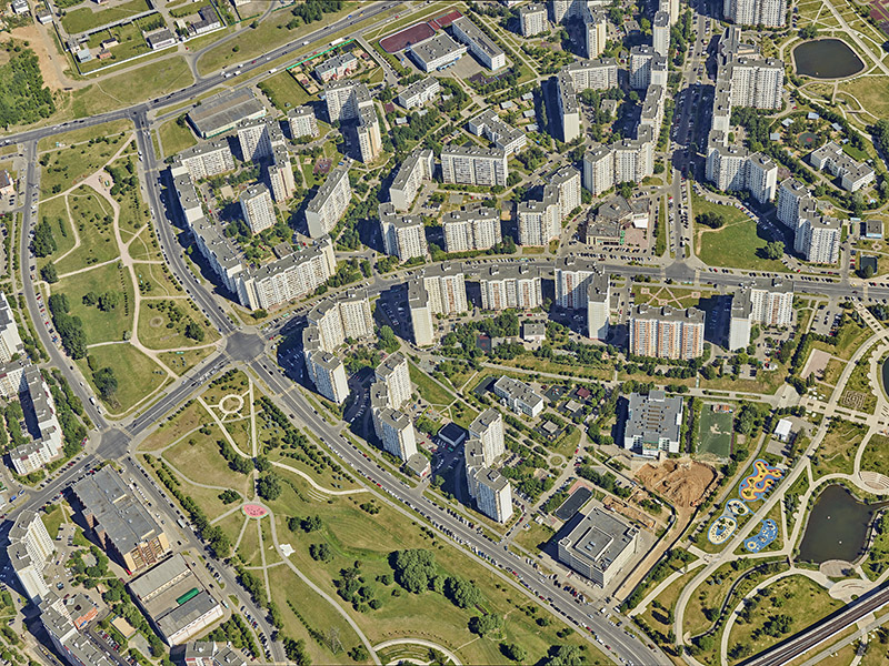
Nadir image
Zoom in to see the level of detail
Deliverable
- Digital elevation models (DEM) and terrain models (DTM) of 1: 2000 scale;
- Polygonal surface model (mesh) for the development area;
- 3D object model consisting of 3D models of capital construction facilities;
- Automatic geometry change detection in the capital construction facilities within the New Moscow territory in the period between two surveys in 2018 and 2019;
- Automated updating of 3D object model databases of capital construction facilities;
- Oracle database to be used in the information system of the unified real estate register.

3D object model Kommunarka, 2018

3D object model Kommunarka, 2019 change detection
Equipment
- RCD-30 Penta Camera in 2018 - 5 sensors, 10 cm / pix GSD @ 1000 m
- IGI UrbanMapper in 2019 - 8 sensors with integrated oblique, nadir, and infrared survey, 5 cm / pix GSD @ 1000 m
- LiDAR AHAB Dragon eye 400 in 2018 and 2019 - 2 laser pulse sources with a frequency of up to 500 kHz each
Software
- Building geometry modeling: virtualcitySYSTEMS, Germany
- Fully automatic model texturing: UVM Systems, Austria


Project details
The specified requirements for 3D object modeling:- The models must be compatible with CityGML v. 2.0 with the level of details (LoD2) of geometric models, and show the contours on the ground as a closed flat polygon without topological defects, as well as building outer walls to be defined by an oriented part of the plane or a part of the solid surface (Brep and / or csg), embrasures of building outer walls, geometric 3D models of roofs, photo textures of walls and roofs;
- Each building model is referenced to the terrain in the MSK 77 coordinate system;
- Each model can have associated attributes (text, graphics, links to external information storage);
- Geometric models shall be built in an automated manner. Walls and roofs shall be also textured automatically;
- The storage format of the textured models for the unified real estate register is Oracle with spatial extension;
- The Internet publishing environment is Cesium, 3DTiles format.
- Automatic Change Detection of the building geometry after the aerial survey 2018 throughout the entire modeling area (1,854 sq. Km), such as: changes in the building height by more than two meters or a changes in the buildings area by more than 16 sq. m;
- Classification of changes: demolished objects, enlarge and/or built-on objects, new construction;
- Saving geometric changes in the database;
- Incremental updating of the 2018 model databases to build models in 2019.

Fragment of orthophotomap 1:2000

Textured polygonal mesh model
Results
- The automatic Change Detection methods for the vast modeling areas have been proved.
- The mass 3D building modelling technology has been debugged at a record pace.
- Comparison of the 3D object model with the cadastral map made it possible to identify the unaccounted buildings and to significantly increase
the tax base.